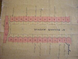
If you, like myself live in an old house, you have probably wondered who lived there before you. Perhaps, if you are a family historian, you have wondered about the neighbourhood your ancestors lived in. My street study is St Ronan’s Avenue; a Victorian cul-de-sac of 28 terraced houses in Southsea. Sadly, now it is an Avenue in name only, the trees have since long gone, replaced with driveways and paving slabs. I started my study by looking at who was living in the street in St Ronan’s Avenue in the 1901 and 1911 censuses, and the 1939 register.

Photo used with kind permission of Mike Hodges
The history of a street, of course, does not necessarily begin when the houses were built; the use of the land before that time is also of interest. Maps are incredibly useful for showing land-use and developments in an area, as we see in sources, such as tithe maps:
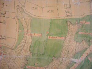
c. 1790
1838
Both maps courtesy of Portsmouth Library and Archive Service, Portsmouth City Council
The tithe maps of 1790 and 1838 shows that the land that St Ronan’s Avenue was built on was arable land, and in 1838 was owned by David Spicer and occupied by a tenant, Joseph Jeram.
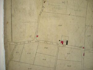
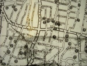
Approx 1880

1898
Both maps courtesy of Portsmouth Library and Archive Service, Portsmouth City Council
Southsea expanded rapidly in the late 1800s. You can see how rapidly building development increased in the space of 18 years. The above maps (courtesy of Portsmouth Library and Archive Service, Portsmouth City Council) show, for example, the plot of land which was bought by the builder Walter William Evans to build St Ronan’s Avenue.
Walter William Evans was a prolific local builder. On 29th September 1897 he paid John Henry Page £2800 for the land that is now St Ronan’s Avenue. The Council Minutes of 1898 record that “it was resolved that it be recommended to the full committee that the following plans be approved: “Builder & Owner W. W. Evans; 36 houses; Seymour Lane, Southsea [now St Ronan’s Road]; Materials to be used in building – brick and slate.” The houses were built sometime between 1898-1900 and were fully occupied by the time the 1901 census was taken on 31st March 1901.

Walter William Evans’s signature on the first sale of one of the St Ronan’s Avenue houses.

The road sign for Evans Road in Southsea which is named after him © Liz Craig
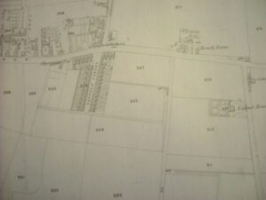
When researching the history of your street, you may come across some unusual maps f. For example, you may also find city engineers plans for renumbering or showing house names. On the left below, is a City Engineer’s Street Plan c1900, which was probably created when the Council adopted (took on the maintenance of) a road, as it did for St Ronan’s Avenue in 1901. The adoption of a road gave numbers to houses which may previously have only had names, or were made up of separately numbered terraces. The houses have had various names over the years, and I have found others on the Pomeroy of Portsmouth website.
Both maps courtesy of Portsmouth Library and Archive Service, Portsmouth City Council
Another fascinating map (above right) shows the locations where bombs (not incendiaries) fell in Portsmouth during the Second World War. Friday 10th June 1941 was to become known as ‘Portsmouth’s Blitz’, as at least 25,000 incendiary (fire) bombs fell on Portsmouth. The raid lasted around seven hours. Planes came over in droves and dropped many flares, which were followed by showers of incendiary bombs and high explosives. British fighter planes went up, and heavy gunfire was maintained. A wall of flares could be seen from as far as seven miles away, the area gradually subsiding into a large, red glowing area flickering in the smoke. Several fires broke out and were still burning at daybreak but had been brought under control. Hundreds of firemen coped with the enormity of their task valiantly. With the veil of darkness lifted, it became apparent that many buildings had suffered, including business premises, several churches, some cinemas, hotels, hospitals, stores, dwellings, and one bomb fell on an ARP post where there were some casualties. Some 57 mobile canteens were set up in the city. A public funeral was held for the victims at Kingston Cemetery the following Friday.
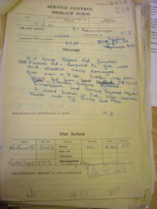
ARP warden’s report
Courtesy of Portsmouth Library and Archive Service, Portsmouth City Council

War Damage Commission Letter
© Liz Craig
An ARP warden’s report of that night (above right) describes a bomb which landed just metres from the end of St Ronan’s Avenue: “Bomb Albert Road Junction Old Fawcett Road – Leopold St. Gas, water and electric mains damaged. Gas main on fire. Trolley lines down. Albert Road from Harold Road to Francis Avenue blocked. Demolition and Rescue Squad required. 2 dead bodies in Rd.” At least one property in the Avenue was rendered uninhabitable by the blast., My neighbours have documentation from the War Damage Commission and H.M. Inspector of Taxes, giving details of claims and War Damage payments.
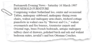
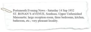
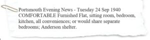
Moreover, newspapers, like those below, provide great descriptions of a property inside and out…

Some properties were later used as guest houses. I have also found adverts for the letting of rooms and flats; some of these give clues as to the internal layout. During the Second World War, adverts for lodgings sometimes describe having air raid shelters, or being suitable for servicemen.
A good resource for property descriptions is the 1910 Valuation Act, which links a map to a field book giving a description of the property including owners, occupiers and value. Unfortunately, the records for Portsmouth no longer survive, but you may be luckier if you’re researching elsewhere in Hampshire.
The most interesting part of any street or neighbourhood study, of course, is the people who lived there. I have not found anyone particularly notable or infamous, there are no landmarks or shops that people can identify with, but doing a street study gives me the opportunity to view Southsea in the 1900s from the very personal perspective of the residents of this street. I’ve already mentioned the censuses, but you can also use electoral rolls and Burgess lists, such as the one below, which gives me details not only of current occupants but, also, of people who previously owned property in St Ronan’s Avenue, but lived elsewhere:
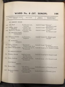
Courtesy of Portsmouth Library and Archive Service, Portsmouth City Council
Directories like Kelly’s are invaluable for establishing dates of changes of occupancy and whether a street has been re-numbered. Current residents have been kind enough to lend me old documents relating to their property. This has been helpful in identifying when and to whom the properties changed hands.
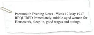
Small ads in the local newspaper give tiny glimpses into the lifestyles, hobbies, and possessions of the inhabitants of the street, as well as the people who worked there. In the first few decades after the street was built, many of the properties had servants. In Victorian and Edwardian times, many houses had live-in servants. Newspaper adverts for servants were more frequent in the 1930s:
Is this what you mean here? People are currently living in St Ronan’s Avenue?


I particularly find the minutiae of daily life in bygone St Ronan’s Avenue fascinating! There were Small Ads asking if anyone had found a lost prayerbook or umbrella. Residents also sold items via the Small ads, such as a black fur coat, a 10’ 6” sailing dinghy, a 15’ whaler (boat), a lady’s 10 Guinea bicycle, a walnut bookcase, and a pianoforte.
Other newspaper articles illuminate the lives of the residents. For example two brothers played cricket for Hampshire. Animal companions are also mentioned; one resident lost their lost stump-tailed sheepdog pup on the common. A fire broke out in No 15 in the early hours of the morning caused by an ember having fallen from the fireplace in the dining room. The occupant extinguished the flames, badly burning his hands, but sadly his valuable parrot was asphyxiated.
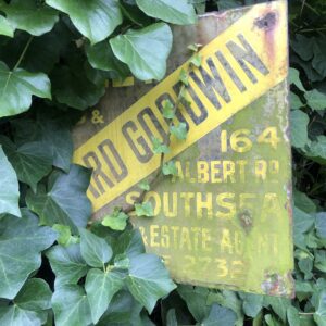
Residents also ran businesses from their homes. No16 worked as an estate agent, and during the Second World War, sold chromed steel identity discs on a bracelet. Mark Bott at No9 was the manager of Midland Cattle Products Ltd in Portchester. Under Government plans, all retail butchers of the food control districts of Portsmouth, Gosport, Fareham and Havant were required to obtain their meat supplies through Portsmouth & District Master Butchers and Cattle Dealers Association. Mark Bott was its secretary and held a meeting at Kimbell’s Restaurant in Osborne Road in Southsea, to explain the scheme to local butchers.
During the Second World War, police carried out identity card checks at ballrooms. There was a report that Joyce Payne of No10 was called up in front of Portsmouth magistrates and fined £1 for failing to carry, or produce on demand, her National Registration Identity Card. Another resident was named in the newspaper as contributing to Portsmouth’s Fighter Fund, which was set up to raise £6000 to pay for an additional plane, which was to have ‘Portsmouth’ emblazoned on the side.
If you are really lucky, you might find photographs of residents in newspapers. Hotel proprietress Mrs Bette Edney of No12 posed in the Piers, Beach and Publicity Committee’s £100 Bikini Girl Contest in June 1958. I have found photographs of other former residents on the genealogy website Ancestry.
Sharing my street study with my neighbours is one of the most rewarding aspects of my research – many are keen to hear about my findings, and have been very generous in sharing information and documents with me. Some residents have lived in the street for a very long time and have passed on their knowledge to me. What I love about these photos is not just the residents, but the glimpses of trees and the houses.
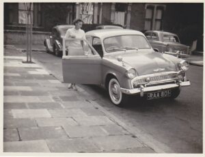
Photo used with kind permission of Claire
Many of the houses still have beautiful original features like fireplaces and ceiling roses, but original features do not have to be attractive to be interesting. All the houses in the street have good sized cellars, consisting of two or three rooms. Each house had a coal hole, which we now use for deliveries of logs. One house still has the original wooden gate which would have contained the coal in that ‘room’. I have not yet established precisely how the cellars were used but there is a fireplace and at least one house had a stove in the cellar.
Some original features are unique to the property. One neighbour remembered being told by his aunt that during the Second World War a neighbour had installed an air raid shelter in their cellar. He mentioned it to another neighbour who confirmed it was her cellar! At least two properties had reinforcements in the cellar, and this one is still there:
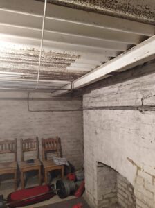
Cellar reinforcements, photo used with kind permission of Wendy
Archaeology is not t just for archaeologists! My husband Ian is a keen gardener, and has unearthed some interesting finds, including a ‘For Sale’ sign, glass, door knobs and tiles. The clay pipes (pictured) were made in a nearby factory in Portchester, which was operational from 1813-1932. There were rumours that a haul of rifles from the First World War were buried in what is now our back garden, but before we bought the extra land, the owner went over the land with a metal detector and found nothing.
© Liz Craig

© Liz Craig
I have set up a website for my street study. Tt is very much in its infancy but eventually each house will have its own page with linked biographies of historical residents. I hope that people will contact me with information and photographs.
A street study is a great way to discover history at a truly local level. You can really get to know the people who lived in your street, or people your ancestors would have known. I hope this blog has inspired some curiosity within you to investigate you own, or your ancestors’ neighbourhood. You are welcome to contact me via my website, or you can find me on social media.
Lastly, I would like to thank Portsmouth Archives’ Senior Archivist Michael Gunton, for kindly giving me permission to use images of documents from Portsmouth History Centre for this article. It was his presentation on his research into people living in Boulton Road in Southsea in 1891 which inspired my street study. He’s giving this talk again on 18 May at Portsmouth Archives.
Further information:
The Society for One-Place Studies: https://www.one-place-studies.org/
The One-Place Studies Directory: https://oneplacestudy.org/
The British Association for local history: https://www.balh.org.uk/

Author: Liz Craig
Bio: Liz has been researching her family history for over 20 years & has diversified into projects which add context to the lives of her ancestors & the places they lived. She has three one-place studies: St Ronan’s Avenue in Southsea, The Temple Lodge Home for Inebriate Women (Torquay) and the village of Dunster in Somerset. She is the current treasurer for The Society for One-Place Studies.
Twitter: @WillsmanOneName
Instagram: @willsmanonename
Website: stronansavenue.wordpress.com
Liz’s other projects include:
One-place study of Dunster, in Somerset: DunsterAncestors.co.uk
The Temple Lodge Home for Inebriate Women: InebriateAncestors.co.uk
Her own family history (work in progress): rootsreconnected.wordpress.com
